


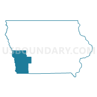
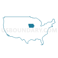
Southwest Iowa--Council Bluffs City PUMA, Iowa
About
Outline

Summary
| Unique Area Identifier | 192940 |
| Name | Southwest Iowa--Council Bluffs City PUMA |
| State | Iowa |
| Area (square miles) | 4,734.85 |
| Land Area (square miles) | 4,709.80 |
| Water Area (square miles) | 25.05 |
| % of Land Area | 99.47 |
| % of Water Area | 0.53 |
| Latitude of the Internal Point | 41.24355050 |
| Longtitude of the Internal Point | -95.41168800 |
Maps
Graphs
Select a template below for downloading or customizing gragh for Southwest Iowa--Council Bluffs City PUMA, Iowa


Neighbors
Neighoring Public Use Microdata Area (by Name) Neighboring Public Use Microdata Area on the Map
- Dodge, Cass, Saunders & Washington Counties PUMA, NE
- Douglas County--Omaha City (Northeast) PUMA, NE
- Douglas County--Omaha City (Southeast) PUMA, NE
- Northeast Nebraska PUMA, NE
- Northwest Central Iowa--Storm Lake, Denison & Cherokee Region PUMA, IA
- Northwest Missouri PUMA, MO
- Sarpy County--Bellevue City PUMA, NE
- South Central Iowa PUMA, IA
- Southeast Nebraska PUMA, NE
Top 10 Neighboring County (by Population) Neighboring County on the Map
- Douglas County, NE (517,110)
- Sarpy County, NE (158,840)
- Pottawattamie County, IA (93,158)
- Cass County, NE (25,241)
- Nodaway County, MO (23,370)
- Carroll County, IA (20,816)
- Washington County, NE (20,234)
- Crawford County, IA (17,096)
- Page County, IA (15,932)
- Otoe County, NE (15,740)
Top 10 Neighboring County Subdivision (by Population) Neighboring County Subdivision on the Map
- Omaha city, Douglas County, NE (408,958)
- Kane township, Pottawattamie County, IA (53,485)
- Bellevue precinct, Sarpy County, NE (50,137)
- Lewis township, Pottawattamie County, IA (12,954)
- Blair city, Washington County, NE (7,990)
- Grove township, Cass County, IA (7,459)
- Garner township, Pottawattamie County, IA (7,222)
- Glenwood township, Mills County, IA (6,486)
- Nodaway township, Page County, IA (6,148)
- Red Oak township, Montgomery County, IA (6,124)
Top 10 Neighboring Place (by Population) Neighboring Place on the Map
- Omaha city, NE (408,958)
- Council Bluffs city, IA (62,230)
- Bellevue city, NE (50,137)
- Blair city, NE (7,990)
- Atlantic city, IA (7,112)
- Red Oak city, IA (5,742)
- Clarinda city, IA (5,572)
- Glenwood city, IA (5,269)
- Shenandoah city, IA (5,150)
- Harlan city, IA (5,106)
Top 10 Neighboring Unified School District (by Population) Neighboring Unified School District on the Map
- Omaha Public Schools, NE (346,311)
- Council Bluffs Community School District, IA (59,804)
- Bellevue Public Schools, NE (44,320)
- Lewis Central Community School District, IA (15,299)
- Blair Community Schools, NE (13,117)
- Glenwood Community School District, IA (11,146)
- Denison Community School District, IA (10,419)
- Plattsmouth Community Schools, NE (9,716)
- Nebraska City Public Schools, NE (9,241)
- Atlantic Community School District, IA (8,807)
Top 10 Neighboring State Legislative District Lower Chamber (by Population) Neighboring State Legislative District Lower Chamber on the Map
- State House District 4, MO (35,512)
- State House District 98, IA (32,864)
- State House District 100, IA (31,218)
- State House District 99, IA (29,553)
- State House District 56, IA (28,514)
- State House District 55, IA (28,147)
- State House District 51, IA (27,718)
- State House District 97, IA (27,696)
- State House District 57, IA (27,393)
- State House District 58, IA (27,255)
Top 10 Neighboring State Legislative District Upper Chamber (by Population) Neighboring State Legislative District Upper Chamber on the Map
- State Senate District 12, MO (169,332)
- State Senate District 50, IA (60,771)
- State Senate District 49, IA (60,560)
- State Senate District 28, IA (56,661)
- State Senate District 48, IA (56,494)
- State Senate District 26, IA (55,929)
- State Senate District 29, IA (54,648)
- State Senate District 18, NE (54,408)
- State Senate District 7, NE (37,866)
- State Senate District 13, NE (36,243)
Top 10 Neighboring 111th Congressional District (by Population) Neighboring 111th Congressional District on the Map
- Congressional District 6, MO (693,974)
- Congressional District 2, NE (638,871)
- Congressional District 1, NE (626,092)
- Congressional District 5, IA (577,453)
Top 10 Neighboring Census Tract (by Population) Neighboring Census Tract on the Map
- Census Tract 301, Pottawattamie County, IA (6,186)
- Census Tract 501.02, Washington County, NE (5,177)
- Census Tract 9669, Otoe County, NE (4,598)
- Census Tract 317, Pottawattamie County, IA (4,514)
- Census Tract 9661, Cass County, NE (4,505)
- Census Tract 101.03, Sarpy County, NE (4,354)
- Census Tract 9660, Cass County, NE (4,301)
- Census Tract 316.01, Pottawattamie County, IA (4,293)
- Census Tract 304.01, Pottawattamie County, IA (4,230)
- Census Tract 1904, Cass County, IA (4,222)
Top 10 Neighboring 5-Digit ZIP Code Tabulation Area (by Population) Neighboring 5-Digit ZIP Code Tabulation Area on the Map
- 51503, IA (36,376)
- 51501, IA (35,406)
- 68107, NE (29,491)
- 68123, NE (27,926)
- 68005, NE (22,132)
- 68108, NE (14,664)
- 68048, NE (12,422)
- 68008, NE (12,285)
- 68112, NE (11,508)
- 51534, IA (9,236)